BRE08: Determination of Areas Near the Shoreline
- ADEUPa
Brest
- Organisation
- ADEUPa Brest Bretagne
- Guillaume Chérel
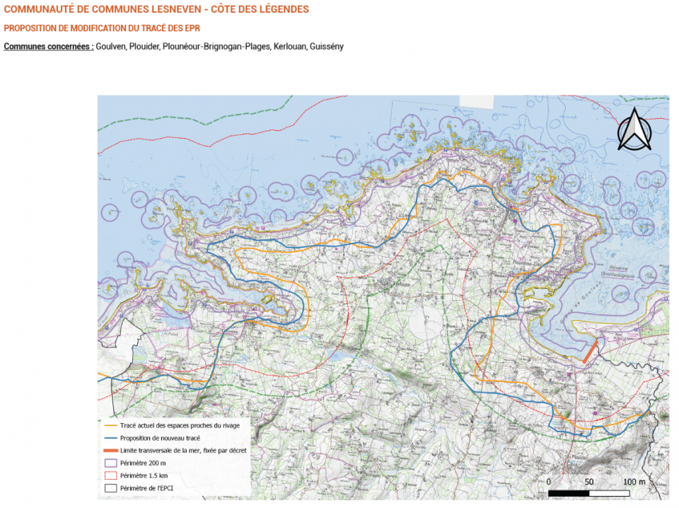
DEFINITION The Urban Planning Code does not precisely specify the methods for their definition and cartographic representation. However, the study of jurisprudence, as illustrated by the example of the Council of State on May 3, 2004, Mme Barrière, No. 251534, allows for the identification of three criteria to consider. An area is considered part of the Areas Near the Shoreline (EPR) when it directly meets at least two of these criteria, in a surrounding context that presents all three simultaneously. These criteria are: the distance from the shoreline, which should be less than 1.5 to 2 km from the shoreline at most, the land-sea co-visibility, as well as the maritime ambiance and consideration of land use and topography, which includes the nature of the terrain (presence of typically coastal natural environments) and visual interruptions towards the sea due to natural elements (such as a forest) or urbanization. Belonging to a sector within the areas near the shoreline implies certain constraints regarding the constructibility and extension of existing buildings. Article L. 121-13 of the Urban Planning Code states that in areas near the shoreline or the banks of inland water bodies, the extension of urbanization must be limited and justified and motivated in the local urban plan according to criteria related to the configuration of the places or the accommodation of economic activities requiring immediate proximity to water. The objective is to avoid linear urbanization along the coast and to encourage new urbanization in retro-littoral zones. The ELAN Law, adopted on November 23, 2018, strengthens the role of Territorial Coherence Schemes (SCoT) in the coastal aspect by identifying and locating all constructible sectors in the Local Urban Plan (PLU). The already urbanized sectors (SDU), included in these identified and located sectors, are only urbanizable outside the areas near the shoreline. The positioning of the line of areas near the shoreline therefore has a significant impact on the constructible sectors of the PLUs. METHODOLOGY The method of work used so far consists of three steps. First, preliminary cartographic preparation is carried out, including an inventory of points to be verified in the field and the creation of routes in a specific order. Then, a survey of the points identified beforehand is conducted in the field, with adjustments and corrections to the route as the fieldwork progresses. Data processing and archiving are carried out simultaneously. Finally, the production of the new route of the Areas Near the Shoreline (EPR) at the Pays scale is documented by an atlas of the surveyed points. The objective of the project will be to adapt the previous methodology to avoid dependence on field surveys.
- What the challenge owner would like to develop over 48h
- An algorithm or calculation method to determinate the Areas Near the Shoreline
- Which skills the challenge owner is looking for
- data analyst
geomatics engineer


