BRE06 Hydrodynamic-aware mapping of Offshore Wind Farms environmental footprint
- chatgpt.com
Brest
- Organisation
- IFREMER
- Jérémie Lehmann
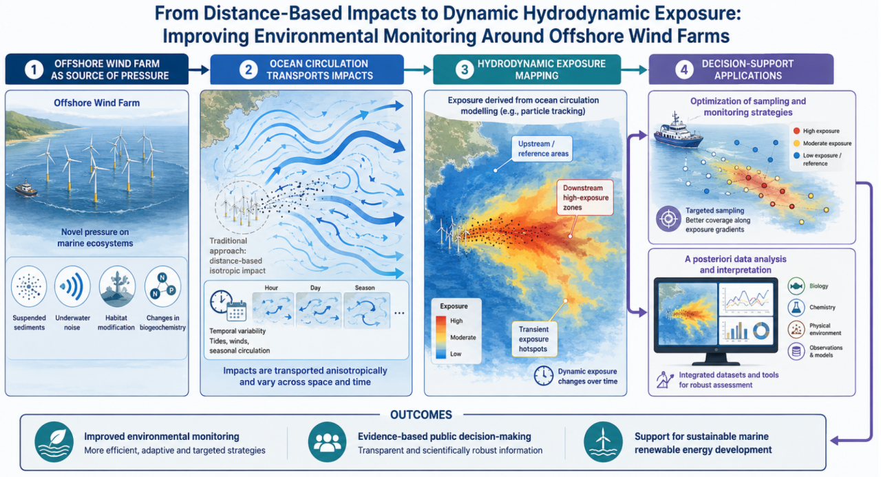
- The expansion of offshore wind farms is a novel pressure on marine ecosystems whose effects on physical, chemical, and biological dynamics remains largely unknown today. One limiting factor when it comes to capturing these effects is due to the fundamentally variable, sometime unpredictable, nature of ocean currents and transport. For instance, characterizing and efficiently visualizing in space and time the area of influence an offshore wind farm remains a major challenge. Traditional approaches generally aim to assess the effects of infrastructure on ecological compartments based on distance. This challenge proposes a different perspective that more carefully accounts for the hydrodynamics: environmental impacts are not spread isotropically but transported by ocean currents, creating exposure zones that vary across space and time. In this context, the challenge is to design an innovative solution that should: characterize hydrodynamic exposure to offshore wind farms using ocean circulation modelling identify relevant impact gradients (upstream/downstream, low vs high exposure areas), provide adequate interfaces for visualizations and customized tools for the various applications considered (optimization of experimental sampling and monitoring strategies, a posteriori data analysis) This challenge is part of the EMOI project and aims to generate concrete solutions for improving the environmental monitoring of marine renewable energy systems and supporting evidence-based public decision-making.
- What the challenge owner would like to develop over 48h
- Idea is to develop a prototype decision-support tool for optimizing offshore environmental sampling strategies around offshore wind farms. Possible outputs may include: - a spatial decision-support system for sampling site selection, helping to define monitoring locations according to hydrodynamic exposure, tidal influence, and sampling frequency, - an interactive mapping and visualization tool transferable to different offshore wind farm sites, - methodologies / concepts for integrating hydrodynamic exposure indicators into the interpretation of in-situ environmental measurements (e.g. phytoplankton, chemistry, water quality indicators).
- Which skills the challenge owner is looking for
- data analyst, IT developer, oceanographer, marine biologist