Sea Tech Week® 2022, the sequel: let's talk about e-navigation
- Brand new! The Shom is making a test dataset available free of charge to users concerned by the S-100 standard. Instituted by the International Hydrographic Organization (IHO), the S-100 standard means upgraded marine charts: more content for more marine safety and real-time decision support. Nathalie Leidinger, Head of the Technical Skills, Research and Innovation Division at Shom, and Vice-Chair of the IHO Hydrographic Services and Standards Committee, explains.
The S-100 is tomorrow
"We have to make chart users aware of the importance of switching to the S-100 and, at Shom, we are there to help them prepare for it", says Nathalie Leidinger. Since the 1990s, SOLAS(1) merchant ships have had electronic charts installed on board ECDIS(2). From 1 January 2026, the first S-100 ECDIS can be marketed and installed on board ships. This date will mark the beginning of a transition phase until 1 January 2029, when all new systems will have to comply with the new IMO resolution on ECDIS performance standards. "2026 is coming very quickly".
The S-100 for an enhanced view of electronic nautical charts
The S-100 chart will provide more accurate and even real-time data. In addition, it will provide multiple decision support services. All of these products are currently being developed by the Shom and work is underway to ensure that they are fully integrated into ECDIS and, more generally, into the entire e-navigation value chain. Of course, in the long term the products will have to be paid for, but as is already the case for nautical charts.
For which users and which uses will the S-100 be used?
To explain, let's take three examples:
- "When a ship enters port, the pilot who assists the ship's captain in difficult passages needs to know precisely where the danger zones are. The S-100 will provide high-resolution data and dynamic information on the ship's under-keel clearance, which is defined in the S-129 standard";
- The route and the arrival and departure times during port calls will be optimised thanks to the weather data and marine currents. "The ship will then be able to adapt its planned passage, i.e. its theoretical route, for an optimised routing". This is an important asset in a world in transition to low-carbon shipping;
- The future S-100 products, which can be directly used by computer, will allow the development of decision support systems for sailors when navigation conditions become hostile, or for remotely operated ships.
The S-100 is primarily intended for commercial vessels that must comply with the SOLAS Convention. ECDIS manufacturers are therefore directly concerned, but so will be ECS manufacturers. ECS(3) are used on pleasure craft and by many professionals, in particular fishermen, who will not all be legally obliged to use S-100 products. Nevertheless, these products will enable the development of additional services that can be integrated into this equipment and that will be of interest to their users.
Port stakeholders (harbour master's office, pilots, etc.) will also be consumers of S-100 products (e.g. to increase the performance of portable piloting equipment (PPU) used by port pilots, who require high-precision data), as well as producers of data that can be added to these products. Port actors regularly carry out bathymetric surveys and have a detailed knowledge of the coastal environment and the uses of ships in their sector.
Another potential user is underwater drone pilots.
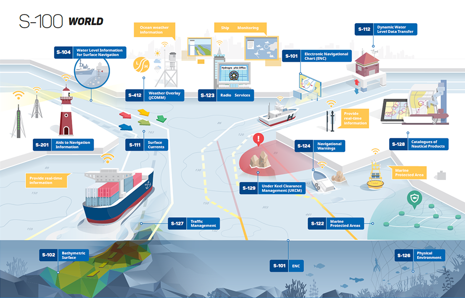
Image courtesy of the IHO Secretariat - permission No. 01/2021 The S-100, but not alone
"We need a global view and any feedback will help meet the needs of users of S-100 products". The Shom is open to all proposals for collaborative projects on the subject.
This is why the French Hydrographic Service proposes, among other things, to play with test data in the St Malo area. Why this area? "Firstly, because we have LIDAR data acquired as part of a project partly funded by the Brittany Region; it is also linked to a project we are carrying out in collaboration with the UK Hydrographic Service entitled "S-100 across the Channel"". This project is based on the development of ECDIS prototypes which will be tested at sea in 2024. The topic was presented at Sea Tech Week® 2022 in the session entitled "What does the IMO e-Navigation S-100 bring to maritime transport"?
With the involvement of all maritime stakeholders, France will be able to become a key player in e-navigation.
(1) Named after the 1974 International Convention for the Safety of Life at Sea(2) Electronic Chart Display Information System. A system for displaying nautical charts in electronic format
(3) Electronic Chart System
- Published on 03/31/2023


